The O-QTM Grid
Here is the globe subdivided by O-QTM three times; each of its 512 faces covers about 1,000,000 square km. The heaviest lines are the octant edges, where 2 adjacent quadtrees meet. Except at the six cardinal vertices of the octahedron, all triangles have six neighbors at verticies. Note the relations between the O-QTM facets and the latitude and longitude gridlines. East-West O-QTM edges are parallels but the others follow neither meridians nor great circles (except for octant edges). Also, QTM facets gradually vary in shape and size; the largest are 1.8 times larger in area than the smallest.

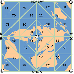
In the map above, however, all QTM grid lines are straight, and all faces are right isoceles triangles. This is the Zenithial Ortho-Triangular (ZOT) world projection centered on the North Pole, with the South Pole occupying all four corners.
ZOT maps can be tiled to fill a wall, but their utility is more computational than aesthetic. Because meridians, parallels and QTM edges are straight in ZOT space, it is an efficient way to determine the QTM quadrants geographic locations occupy.
The map shows QTM first-level quadrant ID codes (QTM IDs); for example, most parts of of Europe are in quadrants 10 and 11, with a smidgen of Spain in 12; some western extremes fall in quadrants 40, 41 and 42. Europe thus resides in two of the eight quadtrees (octants 1 and 4).