Geographic locations can be expressed on a plane
...or on a sphere
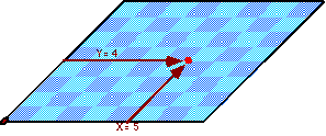
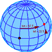
Mathematically, locations are expressed as ordered tuples
|
on a plane: p = f(x, y) |
on a sphere: p = f(lon,lat) |
As these are both two-dimensional surfaces, only two parameters are necessary to specify the location of a point with respect to a fixed origin.
In a computer, coordinate tuples are expressed as integer or floating point numbers having fixed precision (usually 32 bits per ordinate).
![]()
On the earth, which has a circumference of about 40,000 km, a 32-bit floating point number can resolve latitudes and longitudes to about 0.05 arc-second, or around 2 m at the equator (using 7 digits of precision).
When represented in this way, coordinates all have roughly the same precision, no matter where they are (except close to the north and south poles), and regardless of how accurate their sources might have been or what processing they may have received before and during their use.