|
|
|
|
|
|
|
|
DATA: 1:80,000 NOAA/NOS digital nautical charts, vector
coordinates in latitude and longitude
SOURCE: Coastline Extractor --
http://crusty.er.usgs.gov/coast/getcoast.html
EXTENT: 70¤ 14' W - 69¤ 58' W (W-E); 41¤ 14'
N - 41¤ 23' N (S-N)
WIDTH: 22.67 km; HEIGHT: 17.06 km; AREA: 119.9
km2
LENGTH: 125.0 km; POINTS: 867; AVG SEG LEN: 0.14 km
PROJECTION: None for QTM generalization; plat carré
(cosine) for RDP generalization and displayed maps.
INSETS: The smaller maps are drawn to the scale at which the
QTM generalization is intended to be displayed. The scale you see
depends on monitor resolution (images were produced at 75
DPI).
REMARKS: Data digitized from NOS charts at 1:80,000,
possibly with insets digitized from charts as large as 1:10,000,
conditioning unknown. It is possible that that the area around
Nantucket town harbor was digitized from an inset. The 1:80K scale
implies a resolution between 50 and 100 m (assuming a map resolution
of 0.5 mm). As the average line segment length in the dataset is 200
m, this is not an unreasonable formulation.
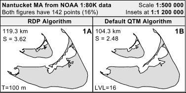
In generalizing the data, RDP (Ramer-Douglas-Peucker
algorithm) tolerances (100, 205, 490 m) were chosen to yield equal
numbers of points as did the corresponding three levels of default
non-hierarchical QTM (quaternary triangular mesh) generalization
(levels 16, 15, 14 -- representing 150, 300 and 600 m ground
resolution respectively).
No special treatment of local sinuosity was applied in these
experiments. The sinuosity statistic gives the path-to-trendline
ratio, averaged across the set of selected points (on a scale of 1 -
7). Note that the sinuosity of RDP solutions is consistently higher
than that of QTM solutions; this is indicative of the "critical
point" bias of RDP.